WEATHER ALERT
Strong storms, gusty winds in the Central Florida forecast before our big cold plunge
Read full article: Strong storms, gusty winds in the Central Florida forecast before our big cold plungeCentral Florida is in for a see-saw style event over the next three days with temperatures climbing toward the upper 80s today and tomorrow, a chance for some strong to severe storms, and then a winter prelude. Here are all the details to get you geared up
A derecho with at least one 99 mph gust swept the Upper Plains and Midwest, the weather service says
Read full article: A derecho with at least one 99 mph gust swept the Upper Plains and Midwest, the weather service saysThe National Weather Service has preliminarily classified overnight storms from the Upper Plains to the Midwest as a derecho.
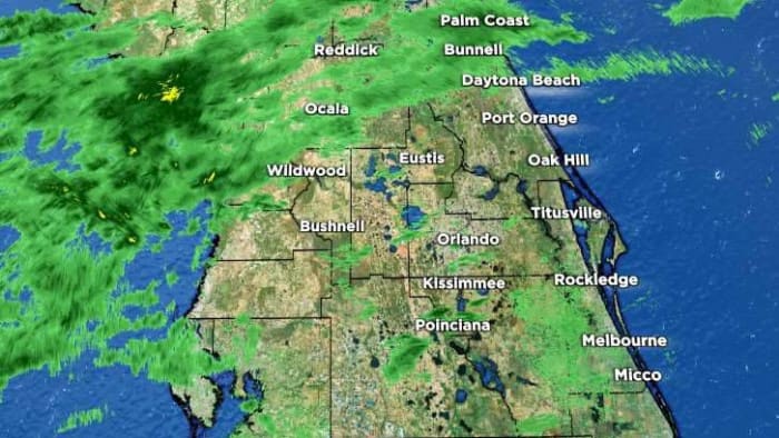
LIVE RADAR: Strong storms once again in Central Florida. Here’s everything to know
Read full article: LIVE RADAR: Strong storms once again in Central Florida. Here’s everything to knowStorm Prediction Center has highlighted central Florida for a level 1/5 severe weather potential this afternoon as our sea breeze reignites similarly to yesterday. Model projections suggest this could be a bit more interior Central Florida this go around, as opposed to the sandwiching we saw with our strongest storms towards the southeast yesterday.
Pinpointing another possible round of strong storms for Central Florida
Read full article: Pinpointing another possible round of strong storms for Central FloridaThe water parks or the beach look like the optimal choice for this weekend in Central Florida with afternoon high temperatures cranking in the low 90s, but as our next rather unseasonably strong cold front approaches, thunderstorms and isolated severe weather are back in your forecast.
Expected wild weather in US gets a rare ‘high-risk’ designation -- the most severe category
Read full article: Expected wild weather in US gets a rare ‘high-risk’ designation -- the most severe categoryWeather forecasters are using a relatively rare “high-risk” designation to warn that a major tornado outbreak appears likely Wednesday.
The next 2 weeks in Florida will take us into summer, winter and back again. Here’s what to know
Read full article: The next 2 weeks in Florida will take us into summer, winter and back again. Here’s what to knowAre you ready for a mix of seasons all at once? Severe weather continues to try to take shape in Central Florida on this last day of March.
April fools? Or will severe weather once again return to Central Florida?
Read full article: April fools? Or will severe weather once again return to Central Florida?Several storm systems are forecast to move across the plains and the eastern U.S. and beneath such warm and unstable air, this could spell trouble for us Floridians. Let's break down what we know together.
Extreme weather expected Saturday gets rarely used 'high risk' designation
Read full article: Extreme weather expected Saturday gets rarely used 'high risk' designationA dynamic storm system threatening to spawn powerful tornadoes and hail as big as baseballs has earned a relatively rare designation from forecasters.
Spring is here! Another looming storm adds to the marathon of threats
Read full article: Spring is here! Another looming storm adds to the marathon of threatsIt may be safe to say spring has officially started to settle in as we prepare to track yet another widespread severe weather producer for the United States. This upcoming low pressure will influence our weather for the upcoming St. Patrick's Day weekend. How much of it heads into our area just ahead.
COUNTY-BY-COUNTY: What to expect with cold front in Central Florida as severe weather risk grows
Read full article: COUNTY-BY-COUNTY: What to expect with cold front in Central Florida as severe weather risk growsChances for damaging winds, small hail and a very isolated tornado exist for many as we move through our Wednesday afternoon.
LIVE RADAR: Thunder and lightning before arctic air blasts Central Florida
Read full article: LIVE RADAR: Thunder and lightning before arctic air blasts Central FloridaOur approaching cold front has a thick band of heavy rain and storms along its leading edge, expected to drape across our viewing area by Sunday afternoon. Beyond that, temperatures will drop excessively with a below-freezing wind chill likely for our northern counties.
Busy weather week ahead as temperatures plummet. Will severe weather return?
Read full article: Busy weather week ahead as temperatures plummet. Will severe weather return?Our next two frontal systems could create some weather ruckus not only bringing frigid arctic temperatures, but the chance we get a stray strong thunderstorm or two as they cut across our viewing area.
LIVE RADAR: Florida to battle through rain and storms before a pleasant New Year’s Eve
Read full article: LIVE RADAR: Florida to battle through rain and storms before a pleasant New Year’s EveSunday is the day our next front arrives, dragging in plenty of moisture, rain, and a few isolated stronger storms for some before we enter a beautiful evening to celebrate the new year.
A severe weather outbreak is coming — how much will Florida see?
Read full article: A severe weather outbreak is coming — how much will Florida see?A large and powerful storm system is slated to start firing later Saturday morning, bringing damaging conditions to our Gulf Coast neighbors. Florida could see a bit more activity from this feature into Sunday.
Conditions ramping up for some BIG weather in Central Florida this weekend. Here’s what to know
Read full article: Conditions ramping up for some BIG weather in Central Florida this weekend. Here’s what to knowForecast models are finally getting a hold of the next weather player expected to move southeast toward Central Florida, highlighting the potential for some stronger storms for our northern viewers.

:strip_exif(true):strip_icc(true):no_upscale(true):quality(65)/cloudfront-us-east-1.images.arcpublishing.com/gmg/XTW4ZY33UNHU5KNP77IVCS3TVI.PNG)
For second week, Deep South under ‘high risk’ for severe weather
Read full article: For second week, Deep South under ‘high risk’ for severe weatherThursday, the Storm Prediction Center highlighted some of the same areas as last week’s outbreak with their rare high risk tag for the likelihood of another tornado outbreak. The high risk category is the highest level on the Storm Prediction Center’s outlook scale and reserved for the most extreme severe weather outbreaks. Severe weather setupThis outbreak has the potential to be even worse than last Wednesday’s outbreak of severe weather. Any discrete, kidney bean-shaped cell in the future radar has the potential to produce long-lived strong tornadoes. These storms will not move into Central Florida as a strong area of high pressure forces these storms to stay north of our area.
:strip_exif(true):strip_icc(true):no_upscale(true):quality(65)/cloudfront-us-east-1.images.arcpublishing.com/gmg/OR73HMV6YRBZRKNWFGAZZW52QY.PNG)
Tornado outbreak likely for parts of Deep South
Read full article: Tornado outbreak likely for parts of Deep SouthParts of the Deep South are in highlighted in a rare high risk. ORLANDO, Fla. – The Storm Prediction Center has highlighted parts of the Deep South in a rare “high risk” for severe weather. A severe weather threat, like the one unfolding Wednesday, only occurs once or twice a year, on average. AdThe severe weather threat moves east Thursday. Severe threat ThursdayA few strong storms will be possible Thursday evening and early Friday across Central Florida.