Hurricane Milton made landfall in Florida near Sarasota on Wednesday night and it’s set to move through Central Florida on its way to the Atlantic.
As it does so, the storm was expected to dramatically increase the risk of flash flooding in the region.
As of 12 p.m. on Thursday, the following areas were under flood-related warnings:
- Flagler County: Storm surge warning in effect until Thursday afternoon for coastal areas
- Lake/Volusia County: St. Johns River near Astor and DeLand was expected to reach major flood stage by Thursday morning
- Seminole County: Flood warning until further notice regarding major flooding forecast for the Little Wekiva River near Altamonte Springs.
- Sumter County: Withlacoochee River near Croom is expected to see minor flooding starting Friday morning.
- Volusia County: Storm surge warning until Friday afternoon for coastal areas
- Volusia County: Coastal high surf advisory until 8 p.m. Friday
Across Central Florida, rainfall totals are forecast to stretch up to 8 inches. A few areas may even see over 10 inches.

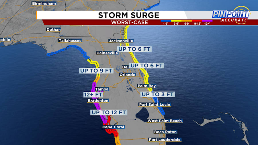
Along the coasts, the NHC is predicting major storm surges — especially where Milton is expected to come aground.
Near Tampa Bay, storm surge could rise as high as 15 feet above sea level, with areas directly north and south forecast to get at least 5 feet.
News 6 viewer shares video of flooding in Port Orange:
On the other side of the state, coastal communities in Flagler, Volusia and Brevard counties could see 3-5 feet of storm surge. As of Tuesday, both Volusia and Flagler counties announced evacuation orders for these areas.

A hurricane is considered a major hurricane when it reaches Category 3 status. Milton is forecast to weaken as it moves through Central Florida.
News 6 viewer shared video of flooding in Edgewater:
For the latest on Milton’s status, check back with ClickOrlando here.


